Exploració per tema "Remote-sensing images"
Ara es mostren els items 1-20 de 48
-
A fully-focused SAR omega-K closed-form algorithm for the Sentinel-6 radar altimeter: methodology and applications

(Institute of Electrical and Electronics Engineers (IEEE), 2024-01-01)
(Institute of Electrical and Electronics Engineers (IEEE), 2024-01-01)
Article
Accés obertThe 2-D frequency-based omega-K method is known to be a suitable algorithm for fully focused SAR (FF-SAR) radar altimeter processors, as its computational efficiency is much higher than equivalent time-based alternatives ... -
A learning approach for garbage and debris identification
(Universitat Politècnica de Catalunya, 2020-10-30)
Projecte Final de Màster Oficial
Accés obert
Realitzat a/amb: Technische Universiteit DelftPlastic pollution in the sea is causing several environmental and economic problems all over the world. It is estimated that around 8 million tonnes of plastic every year end up in the sea, the vast majority coming from ... -
A Method to determine secondary codes and carrier phases of short snapshot signals
(2022-12)
Article
Accés obertRecently, the Snapshot Real-Time Kinematic (SRTK) technique was demonstrated, which aims at achieving high accuracy navigation solutions with a very short signal collection. The main challenge in implementing SRTK is the ... -
Anàlisi fenològic de la vegetació amb sèries temporals d'NDVI a Catalunya i la seva relació amb el canvi climàtic
(Universitat Politècnica de Catalunya, 2019-11-13)
Treball Final de Grau
Accés obertEn les últimes dècades ha sorgit una gran interès en estudiar la dinàmica de la vegetació com a indicador del canvi climàtic a causa de l'alta sensibilitat de la mateixa a variables climàtiques fonamentals, com poden ser ... -
Análisis de la sostenibilidad en Bolivia a partir de imágenes satelitales nocturnas.
(Universitat Politècnica de Catalunya, 2018-07)
Projecte Final de Màster Oficial
Accés obertHoy en día la utilidad de las imágenes satelitales se ha incrementado, debido a la mejora y continúa de satélites y sensores, así como el almacenamiento y la distribución de los datos que se recolectan. Debido a que las ... -
Applied Anomaly Detection on unsupervised detection of marine mammals
(Universitat Politècnica de Catalunya, 2021-01)
Projecte Final de Màster Oficial
Accés obert
Realitzat a/amb: Universitat Rovira i Virgili / Universitat de BarcelonaIn this report, techniques for Anomaly Detection are explored with the aim of automating the process of detecting marine mammals in satellite imagery. This can be later be applied to extract and prepare data for an object ... -
Approach to velocity and acceleration measurement in the Bi-Directional SAR imaging mode

(Institute of Electrical and Electronics Engineers (IEEE), 2012)
(Institute of Electrical and Electronics Engineers (IEEE), 2012)
Text en actes de congrés
Accés restringit per política de l'editorialThis paper presents an initial analysis of the possibilities for velocity and acceleration m easurement with the Bi- Directional SAR imaging mode (BiDi). It comprises single satellite single path acquisitions as well ... -
Atmospheric phase screen retrieval from GEOSAR long term acquisition
(2012)
Text en actes de congrés
Accés restringit per política de l'editorialIn this paper, a GEOSAR mission with typical LEOSAR parameters but longer integration time to increase the received power is presented. Such systems can provide images of large areas with continuous monitoring. The revisit ... -
Automatic detection of endangered species in video and satellite images using deep learning
(Universitat Politècnica de Catalunya, 2020-09-08)
Projecte Final de Màster Oficial
Accés restringit per decisió de l'autorIn the context of the current global biodiversity crisis, several whales and cetacean species are among the most endangered animals on Earth due to past extensive whaling and to the current impact of human activities. This ... -
Automatic mapping of seagrass beds in alfacs bay using Sentinel-2 imagery
(2019)
Comunicació de congrés
Accés obertSeagrass are marine flowering plants that form extensive meadows in shallow coastal waters. They play a critical role in coastal ecosystems by providing food and shelter for animals, recycling nutrients, and stabilizing ... -
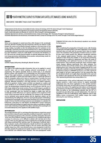
Bathymetric surveys from SAR satellite images using wavelets
(SARTI, 2021)
Article
Accés obertWhen waves propagate in coastal areas they sufer changes in the wavelength and wave direction resulting from the interaction with the sea bottom. In SAR images, the waves can be identify through variations in the gray tones ... -
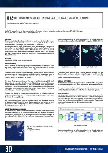
Big plastic masses detection using satellite images & machine learning
(SARTI, 2021)
Article
Accés obertThis communication describes a preliminary research on detection of big masses of plastic (marine litter) on the oceans and seas using EO (Earth Observation) satellite systems. Free images from the Sentinel 2 (Copernicus ... -
Color measurement and distinction of textile samples using a multispectral imaging system
(2009)
Text en actes de congrés
Accés restringit per política de l'editorial -
Comparative study of upsampling methods for super-resolution in remote sensing
(International Society for Photo-Optical Instrumentation Engineers (SPIE), 2019)
Text en actes de congrés
Accés obertMany remote sensing applications require high spatial resolution images, but the elevated cost of these images makes some studies unfeasible. Single-image super-resolution algorithms can improve the spatial resolution of ... -
Desenvolupament d’un algoritme per a la detecció i obtenció d’àrees cremades als Andes, a partir d'imatges del satèl·lit Landsat
(Universitat Politècnica de Catalunya, 2015-09)
Projecte/Treball Final de Carrera
Accés obertAquest projecte té com a objectiu desenvolupar una metodologia, a partir de dades obtingudes per teledetecció, que permeti detectar i quantificar les àrees cremades, causades pels incendis, que es produeixen en un dels ... -
Desenvolupament d’una metodologia per la detecció i el càlcul d’àrees cremades en boscos de boira tropicals i pastures d'alta muntanya dels Andes
(Universitat Politècnica de Catalunya, 2013-11)
Projecte/Treball Final de Carrera
Accés obertL’objectiu d’aquest projecte és el de desenvolupar una metodologia basada en la teledetecció que permeti detectar i quantificar correctament les àrees cremades (burn scars) que deixen al seu pas els incendis en un dels ... -
Detección de incendios
(Universitat Politècnica de Catalunya, 2017-07-07)
Treball Final de Grau
Accés obertDado el fuerte impacto ambiental que producen cada año los incendios, se ha realizado un estudio del incendio de Òdena que sucedió el pasado 27 de julio del 2015 usando la teledetección con tal de cuantificar la severidad ... -
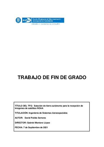
Estación de tierra autónoma para la recepción de imágenes de satélites NOAA
(Universitat Politècnica de Catalunya, 2021-09-14)
Treball Final de Grau
Accés obertPolar meteorological satellites are one of the main environmental information sources about Earth and atmosphere, being capable to scan the entire globe. The ones of this type managed by the U.S. NOAA (National Oceanic and ... -
Estudi de l' evolució de la vegetació a partir de les precipitacions en el Parc Natural Cabo de Gata-Níjar utilitzant imatges de satèl·lit
(Universitat Politècnica de Catalunya, 2013-12)
Projecte/Treball Final de Carrera
Accés obertAquest projecte recull un estudi de l'evolució de la vegetació després de saber les precipitacions rebudes al territori del Parc Natural de Cabo de Gata-‐Níjar, durant el període que va del 2000 fins el 2012, utilitzant ... -
Estudi de l’evolució de la vegetació en la zona del llac Txad des de l'any 2000 fins al 2014 amb imatges dels satèl·lits SPOT, MODIS i PROBA-V
(Universitat Politècnica de Catalunya, 2015-06-23)
Treball Final de Grau
Accés obertEn aquest treball s’estudia l’evolució de la vegetació en la zona del llac Txad des de l’any 2000 fins a l’any 2013 per mitjà d’anàlisis de sèries temporals d’imatges d’índex de vegetació de diferència normalitzada (NDVI) ...