Mostra el registre d'ítem simple
Aixecament per fotogrametria terrestre d’una paret rocosa del puig de L’Olordà
| dc.contributor | Buill Pozuelo, Felipe |
| dc.contributor | Lantada, Nieves |
| dc.contributor.author | Nicolas Marti, Raül |
| dc.contributor.other | Universitat Politècnica de Catalunya. Departament d'Enginyeria del Terreny, Cartogràfica i Geofísica |
| dc.coverage.spatial | east=2.0549702000000707; north=41.41194949999999; name=08980 Sant Feliu de Llobregat, Barcelona, Espanya |
| dc.date.accessioned | 2016-01-18T15:15:10Z |
| dc.date.available | 2016-01-18T15:15:10Z |
| dc.date.issued | 2015-10 |
| dc.identifier.uri | http://hdl.handle.net/2117/81623 |
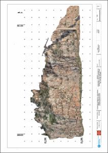
| dc.description.abstract | In this work was defined all processes to be followed to achieve the main objective, which is to create a 3D model of the quarry of Puig's Olorda. The 3D model was made from terrestrial and aerial photographs, the last have obtained from a drone, and to complete the higher part of the quarry also was a survey of a part of the wall is covered by a small embankment. To reference the model globally before the photographs, they were put some targets in the quarry that gives the coordinates with the classical topography. The result is a 3D model whose geo-referenced, for this model I extract orthophotos and elevation view from the quarry, because it has a considerable size, 200 meters long and 70 meters high, and the aim is to visualize both in the model and in the finally, the cracks and faults wall, to study the risk of release. Therefore, the model must be done with the greatest precision and quality possible. |
| dc.language.iso | cat |
| dc.publisher | Universitat Politècnica de Catalunya |
| dc.rights | Attribution-NonCommercial-NoDerivs 3.0 Spain |
| dc.rights.uri | http://creativecommons.org/licenses/by-nc-nd/3.0/es/ |
| dc.subject | Àrees temàtiques de la UPC::Enginyeria civil::Geomàtica::Fotogrametria |
| dc.subject.lcsh | Surveys |
| dc.subject.lcsh | Photogrammetry |
| dc.title | Aixecament per fotogrametria terrestre d’una paret rocosa del puig de L’Olordà |
| dc.type | Bachelor thesis |
| dc.subject.lemac | Fotogrametria terrestre -- Catalunya -- Puig d'Olorda |
| dc.subject.lemac | Aixecaments topogràfics – Catalunya |
| dc.rights.access | Open Access |
| dc.audience.educationlevel | Grau |
| dc.audience.mediator | Escola Politècnica Superior d'Edificació de Barcelona |
| dc.provenance | Aquest document conté originàriament altre material i/o programari no inclòs en aquest lloc web |
| dc.audience.degree | GRAU EN ENGINYERIA GEOMÀTICA I TOPOGRAFIA (Pla 2010) |